Sign in to see all reviews and comparisons. It's Free!
By clicking Sign In with Social Media, you agree to let PAT RESEARCH store, use and/or disclose your Social Media profile and email address in accordance with the PAT RESEARCH Privacy Policy and agree to the Terms of Use.
Text Analytics Software
Now Reading
WordStat features geospatial intelligence module to transforms unstructured text into interactive maps
WordStat features geospatial intelligence module to transforms unstructured text into interactive maps
WordStat features geospatial intelligence module to transforms unstructured text into interactive maps : Provalis Research new version of text analytics software, WordStat 7.1 includes a geographic information system (GIS) mapping and data editing module, allowing businesses to obtain insightful geospatial intelligence. This innovative module provides users with the ability to create a wide range of maps out of pure text data.The analysis of unstructured text data with geographic affinity poses some challenges when an organization is seeking to obtain insightful results. “The implementation of tools currently on the market is a complex process that usually requires in-depth geographic information science (GIS) knowledge,” says Normand Péladeau, Provalis Research’s CEO. “Our objective was to allow text analysts to easily perform spatial distribution analysis taking into account multiple variables.”
Geospatial analysis requires geographic coordinates. For situations where exact latitude and longitude are not available, Provalis Research’s product offers an integrated geocoding web service that converts location names, postal codes and IP addresses into geographic coordinates.
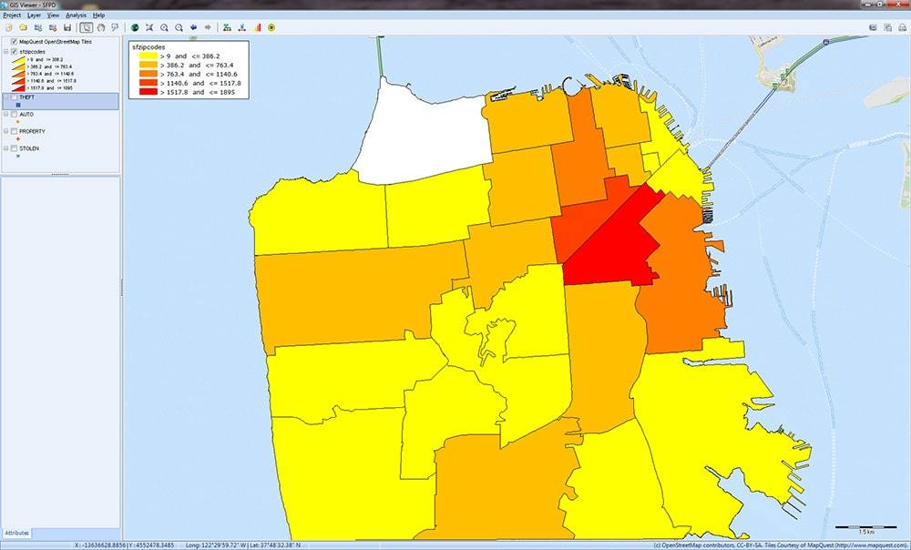
The geospatial intelligence module enables users to create three different types of maps, based on geocoding data in a simple, fast and user-friendly manner. Interactive maps show data points, which can easily be filtered or annotated to highlight the required information. Distribution, or choropleth maps represent statistical variables using color-coding, and heat maps allow users to visualize data point density. Conveniently, WordStat 7.1 has the ability to animate a sequence of map results in order to demonstrate changing results over time, or any relationship with another numerical variable, creating a video-like presentation.
The benefits of WordStat 7.1’s geospatial analysis module span across a wide range of industries. “The tool empowers analysts with the unique ability to produce efficiently plausible visual displays within one analytical process that enables decision makers to get a quick grasp on analytic results with geographic references,” says Dr. Uwe Ewald, Director of the International Justice Analysis Forum. “The mapping outcome is generated in seconds or just a few minutes, eliminating the need to rely on geospatial experts or additional GIS-software,” adds Dr. Ewald.
Distribution Maps
Using WordStat 7.1, retailers can determine where and when most of their sales occur. Customer service divisions can profile their clients’ support needs based on trends emerging from certain geographic locations. Insurance firms, municipalities and law enforcement departments can visually represent the spatial distribution of incidents or crimes in relation to location, time or any other numerical variable.
Provalis Research is a world-leading developer of text analysis software with ground-breaking qualitative, quantitative and mixed methods programs. Developing text analysis programs for more than 18 years, Provalis Research has a proven record of accomplishment in designing and bringing to market tools that today are essential to researchers and analysis specialists worldwide.


By clicking Sign In with Social Media, you agree to let PAT RESEARCH store, use and/or disclose your Social Media profile and email address in accordance with the PAT RESEARCH Privacy Policy and agree to the Terms of Use.